 Read article: LEGO interferometer aims to put quantum science in the spotlight
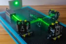
LEGO interferometer aims to put quantum science in the spotlight
University of Nottingham researchers have developed a fully functional LEGO interferometer kit